Lizard Head Pass
A high San Juan pass south of Telluride, watched over by a crumbling volcanic spire.
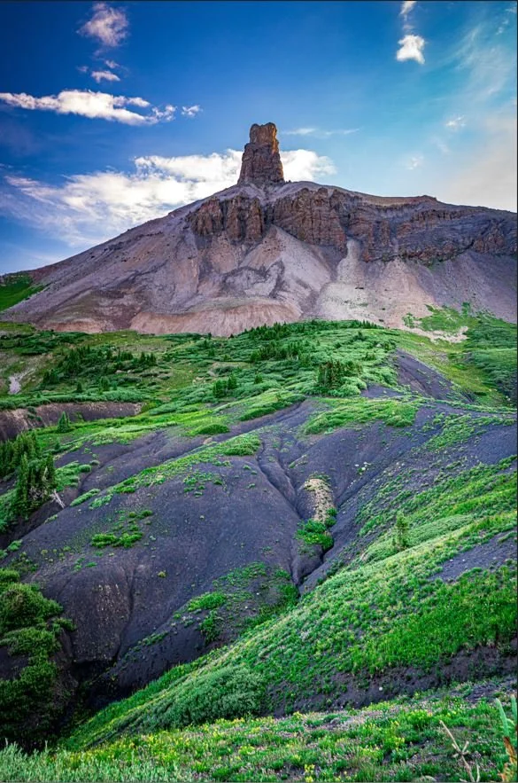
About Lizard Head Pass
Lizard Head Pass crosses the San Miguel Mountains at 10,222 feet on Colorado Highway 145, about 10 to 12 miles south of Telluride on the San Juan Skyway. It sits on the line between San Miguel and Dolores counties and between two national forests.
The pass takes its name from Lizard Head, a roughly 13,100-foot spire of volcanic rock that juts from the ridge to the west. Behind it rise three fourteeners: Wilson Peak, Mount Wilson and El Diente. Open meadows on the pass fill with wildflowers in midsummer, and Trout Lake sits just below on the north side.
It is an easy roadside stop with a big payoff: a pullout and interpretive area, trails heading into the Lizard Head Wilderness, and some of the most dramatic peaks in the San Juans in one view.
At 10,246 feet along the San Juan Skyway, this is one of the highest paved passes in the state and a genuine highlight of a drive between Telluride and Rico. The pass itself is the reward here — pull off and the surrounding peaks do the rest of the work, especially in golden hour when the jagged spire the pass is named for catches direct light while everything around it stays in shadow.
History
The Rio Grande Southern Railroad crossed here until 1952. The steep grades were a constant problem for the line and helped lead to its famous Galloping Goose railcars. The rail grade is now partly followed by trails.
Lizard Head itself is made of volcanic ash-flow tuff sitting on older sedimentary rock, and it is notoriously loose; its profile changed after a rockfall in the early 1900s. Albert Ellingwood and Barton Hoag made the first ascent in 1920, and it's still considered one of the hardest summits in Colorado. The Lizard Head Wilderness, which includes the three fourteeners, was designated in 1980.
Photographing Lizard Head Pass
Best light: Lizard Head and the Wilsons sit west of the pass, so from the road their east faces are lit head-on in the morning and silhouetted at sunset. Mid-July to early August brings the wildflower meadows, and late September adds gold aspens on the slopes around Trout Lake.
Shots to look for
- Lizard Head spire with a telephoto from the pass overlook, isolating its jagged profile against the sky.
- Wildflower meadows on the pass in the foreground with Lizard Head and the Wilson massif behind, using a wide lens.
- Trout Lake reflecting the surrounding peaks and fall aspens from the lake's shore just north of the pass.
- Sunrise light on Sheep Mountain and the San Miguels from roadside pullouts.
Photo tips
- Use the overlook and designated pullouts; CO 145 is a fast highway with limited shoulders.
- Weather changes fast at 10,000-plus feet; afternoon storms are routine in July and August.
- Bring a long lens; Lizard Head is several miles from the road.
- Trailhead parking at Hope Lake and other nearby trails is limited.
Know before you go
- The pass is on a paved state highway and normally open year-round, but winter storms can close or slow it.
- Trails from the area enter the Lizard Head Wilderness, where wilderness rules apply.
- Climbing Lizard Head is a technical, dangerous climb on notoriously loose rock, not a hike.
- Elevation is over 10,000 feet; take it easy if you've just arrived from lower country.
Frequently asked questions
Where is Lizard Head Pass?
On Colorado Highway 145 about 10 to 12 miles south of Telluride, on the San Juan Skyway between Telluride and Rico.
How high is Lizard Head Pass?
The pass is 10,222 feet. The Lizard Head spire above it rises to roughly 13,100 feet.
When do the wildflowers bloom at Lizard Head Pass?
The Forest Service lists mid-July to early August as the best time for wildflowers.
Featured in: Best Wildflower Hikes in Colorado
Combine it with
Trout Lake · Telluride · Ophir Pass · Hope Lake Trail
More Colorado spots
Sources & further reading: en.wikipedia.org · en.wikipedia.org · fs.usda.gov · en.wikipedia.org. Conditions, fees and rules change; check with the managing agency before you go.